

How a street gets its direction
Surveying, terrain, property, and planned views establish a street's bearing. That bearing later sets the dates of an urban henge.
By Evaldas Kazlauskas · 7 min read
At sunset, a straight street can appear to end in the Sun. The disk sits between the buildings, low enough to fill the gap, and the road seems to have been laid for it. The street's direction usually came from something closer to the ground: a survey, a property boundary, the shape of an island, a gate, or a planned view toward a monument.
The Sun's part is recurrent. Its rise and set points move along the horizon and return through the year. The local part is the street bearing, an angle fixed by decisions that may be centuries old. An urban henge occurs when the two directions match.
Many accounts explain the solar motion and call the street simply "the grid." That shorthand removes the feature that differs from city to city. One grid lies close to the compass. Another is rotated to fit a shoreline. A long avenue may have been set toward a palace or an arch. An older street may turn around a slope or a vanished field boundary. These decisions determine whether a long alignment is possible and when it appears.
The urban historian Spiro Kostof grouped city plans into three broad families: the grid; the city accumulated around terrain, routes, markets, walls, and property; and the grand manner of long axes and directed views. The categories overlap, but each tends to produce a different kind of street line.
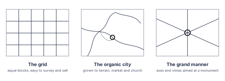
Three broad forms adapted from Spiro Kostof: a regular grid, streets accumulated around local conditions, and monumental axes directed toward a planned view.
The grid as a land instrument
Grids long predate the person most closely associated with them. Kostof traces the name of the planned grid to Hippodamus of Miletus in the fifth century BCE, while noting that gridded settlements and colonial towns were older. What later writers attributed to Hippodamus was a larger proposition: a city could be laid out as a complete arrangement before most of it had been built.
The form recurs because it is useful. Rectangles are comparatively easy to survey, record, divide, tax, transfer, and build on. A repeated block also allows a plan to extend across undeveloped land without inventing a new relation at every parcel.
That administrative usefulness can dominate the plan. Kostof quotes Lewis Mumford's complaint that a municipal engineer with a T-square could "plan" a metropolis without training as an architect or sociologist. The point is not that geometry itself has a political character. A regular geometry becomes consequential through the work assigned to it.
Manhattan provides a clear case. The Commissioners' Plan of 1811 imposed a regular system of streets and avenues across most of the undeveloped island above the existing city. Its accompanying remarks discuss regularity, convenience, construction, and economy. When the commissioners explained the limited number of public squares, they referred directly to the high price of land.
The plan also had a local predecessor. In 1796, surveyor Casimir Goerck divided municipal land in the middle of the island into regular lots for sale. The 1811 plan extended a similar method across a much larger area and fixed the lines along which streets, blocks, façades, and property would later be built.
Manhattanhenge begins with that geometry. No known planning document gives the sunset a role in the grid. The effect appears because the plan survived with enough continuity for its bearing to remain visible.
Turning the grid
A regular grid still has to face a direction.
Some grids lie close to the cardinal axes. Much of Chicago's street grid reflects the near-cardinal survey frameworks used across the region. Many downtown streets therefore run close to true east and west, and the western sunset reaches those bearings near the equinoxes.
Other grids are turned to fit local ground. Manhattan's avenues run about twenty-nine degrees east of true north; the cross streets point about twenty-nine degrees north of true west. The avenues follow the island's general length, while the cross streets make a shorter passage from one side to the other.
That rotation moves the alignment away from the equinoxes. Looking west along a Manhattan cross street means looking north of due west. The setting point reaches that direction on two passages around the June solstice, one before and one after it.
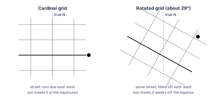
A near-cardinal street meets the western sunset near the equinoxes. Rotating the street moves the two alignment periods toward the relevant solstice.
The same rule applies elsewhere. The street bearing does not acquire a date until it is compared with the Sun's annual range. Turn the street and the two matching periods move with it. The amount of calendar movement is not constant, because the sunset point changes more quickly near the equinoxes and more slowly near the solstices.
Streets accumulated over time
Kostof's second family is usually called organic or diagrammatic urban form. Such streets were not necessarily unplanned. They were planned in smaller decisions and at different times.
A route may follow the easiest gradient. Another approaches a gate, a bridge, a market, or a church. A wall fixes an edge. A property owner refuses a cut. A stream is covered but leaves its curve in the street above. Short straight sections meet at bends that make sense on the ground even when the whole plan looks irregular from the air.
Le Corbusier dismissed this kind of route as the "Pack-Donkey's Way." Kostof treats it as a record of accumulated use.
A street bends because something once made it bend.
For an urban henge, the bend matters more than the label attached to the plan. A long view requires enough of the route to hold approximately one bearing. A curved street may offer several brief openings, each with a different direction, without producing a single corridor in which the whole disk appears centred.
This is why widely named events are common on grids and long avenues. Older irregular districts can still contain them, especially where a later road, embankment, railway approach, or redevelopment cut a straighter line through the existing fabric. The origin of the district and the geometry of the selected street should be considered separately.
The monumental axis
In Kostof's grand manner, avenues lead toward palaces, arches, domes, hills, or civic monuments placed to close the far end of the composition. Building such an axis requires coordinated authority, land, and the power to clear or reshape what lies in its path.
Paris contains many of the form's clearest examples. The Champs-Élysées developed as part of a ceremonial and perspectival axis, later terminated by the Arc de Triomphe. Its straightness and scale make a solar alignment conspicuous, but the documented focal point is terrestrial.
The distinction is easy to miss in a photograph. A low Sun occupying the same axis as a monument can make the whole composition look solar. Planning history may show that the avenue was directed toward the monument and that the sunset arrived on the line because its annual azimuth range includes the avenue bearing.
Some structures and settlements do contain stronger evidence of intended solar effects. Those cases need more than a matching direction. They are considered separately in the third article of this series.
What remains in the line
The three urban forms leave different conditions for an alignment.
In Manhattan, the relevant bearing comes from a development grid fitted to a long island. In central Chicago, it comes from a near-cardinal survey order. In Paris, it comes from a monumental avenue designed around a distant built focus.
The same calculation can be applied to each street. The result does not make their histories equivalent. It identifies the dates on which the Sun reaches a direction already present in the city.
On West 42nd Street, the 1811 plan is still visible in the curb, the façades, the crossings, and the long western opening. Twice each year the sunset reaches that bearing. Cameras rise and traffic pauses. A few minutes later the disk has dropped behind New Jersey and the signals change again.
Sources
- Spiro Kostof, The City Shaped: Urban Patterns and Meanings Through History. Thames and Hudson, 1991. See the chapters on the grid, organic urban form, and the grand manner.
- Spiro Kostof, The City Assembled: The Elements of Urban Form Through History. Bulfinch Press and Thames and Hudson, 1992.
- Commissioners of Streets and Roads in the City of New York, Remarks of the Commissioners, 22 March 1811. Use the transcription held by the Museum of the City of New York.
- William Bridges, This map of the city of New York and island of Manhattan, as laid out by the commissioners appointed by the legislature, April 3d, 1807. 1811. Library of Congress Geography and Map Division.
- New York Public Library, Commissioners' plan of Manhattan Island and report with related materials, Manuscripts and Archives Division, MssCol 605.
- Street bearings and alignment periods: Streethenge catalogue and calculation engine. Record the engine version and altitude convention used for publication.